- Techincal fleet
- Completed projects
- Hydrography
- Contacts
- en
- ru
Hydrography
We carry out hydrographic survey works on land and water according to client's requirements and applicable international standards.
Our specialists are equipped with the most modern equipment for quality implementation of hydrographic works of different levels of complexity.
Research
- Standard work order
- Geodesic works
- Hydrological works
- Hydrographical works
- Custom works
- Equipment and software
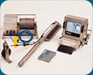
Equipment and software
-
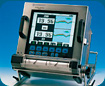
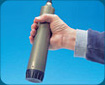
MARIMATECH E-SEA SOUND 103
Technical Specification -
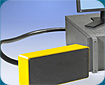
MARIMATECH E-SEA SCAN 800
Technical Specification -
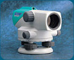
SOKKIA C300
Technical Specification -

SOKKIA SET510
Technical Specification -
MARIMATECH E-SEA MAG 300
Technical Specification -
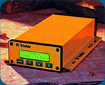
MARIMATECH E-SEA TIDE
Technical Specification -
TRIMBLE MS750
Technical Specification -

E-SEA SAT 2020
Technical Specification -
ODOM ES3-M
Technical Specification -
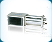
RESON HydroBat
Technical Specification -

HYPACK Software
Technical Specification -
Trimble Software
Technical Specification -
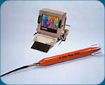
Marimatech 1820 CTD
Technical Specification
Standard working order at the construction site
Stage 1
Gathering information about the site.
Stage 2
Engeneering enquiery
- site's reconnaissance inspection
- equipment installation and adjustment
- site's topography
- construction of a gauge, monitoring of water level fluctuations, fulfillment of hydrological computations
- soil sampling and laboratory analysis
- hydrographic survey
- sonar survey to detect objects of technogenic and natural origin towering above the bottom. Magnetometric survey of the site to detect various metal objects.
- processing the information received, a preliminary calculation of dredging and land reclamation, development of a report on the engineering survey
Stage 3
Geodetic and hydrographic support of the dredging and land reclamation. Regularly, depending on technical specifications, we conduct hydrographic soundings and leveling the alluvial area.
Stage 4
the final calculation of the volume of dredging and land reclamation. Drafting a technical report.
Geodesic works
Establishment of horizontal and vertical justification. Geodetic points are laid at the site (1 point for a 5-10ga) and using satellite equipment coordinates of these points are marked in a WGS-84 coordinate system. a catalog of origin and marks reference points is compiled, or local coordinate system (with the help of the calculated "key transition" from one coordinate system to another).
From the starting points of developing crew geodetic network, built as a theodolite and leveling moves. Angles and lines in the network are measured by electron imaging instrument. Permissible angular residuals are defined by the following formula:
f = +-1sq(n)
where n - number of measured angles in the course of theodolite.
Valid discrepancies in technical leveling speeds are determined by the following formula:
f = +-10sq(n)
Where n - number of tripods in the course of leveling.
According to the results of adjustment, the coordinates of points horizontal and vertical justification of the scheme are compiled into a catalogue. Analysis was performed on a package of specialized geodetic CREDO software.
Topographic survey
Within the specified boundaries of work (according to the technical task) topographic survey is performed (scale 1:500 or smaller, and a special scale of 1:200). Topographic mapping is done in using a tachometrical method using electronic total station (with a record of shooting pickets in memory of the electronic total station). When carrying out a topographic mapping (1:500 scale), coordinating and measuring of all existing buildings is done in up to 10 cm measuring unit. Surveying materials are then processed using the specialised CREDO software.
Terrain digital model
Surveying results are presented in electronic form as a digital terrain model format (DXF), where different layers of information are displayed (buildings, poles, roads, terrain, elevation marks, water wells, vegetation, etc.). Plans of underground utilities (sewers, water, electricity, etc.) are then added to the digital model on separate layers. the model can be also edited and any additional information can be added to it at any later stage.
Hydrological works
Based on the gathered data, a brief hydrometeorological sketch (wind mode, level mode, wave mode, recorded, etc.) is compiled.
To ensure that dredging at the site is successful, a tidal gauge in the form of tide gauge and water level recorder is constructed. All the markings of the site are done relative to "0" depth of the site.
the operating and main frames of the level of fasting are fixed in the area of tidal gauge. Relative to the initial frame, the leveling of tide staff, workers and the main frame is performed.
Inspections at the tidal gauge are performed during the whole course of the project.
Hydrographical works
Sounding at the facility are made with a Echo sounder Marimatech E-Sea Sound 206 or 106 small boat echo sounder (accurate determination of depth +-1cm). Positioning is performed using a GPS Trimble MS-750 or E-Sea Sat 2020 DGPS Positioning System (accuracy + -0.5 m site). for maximum accuracy a multibeam sonar dredging with a compensator roll ODOM ES3-M is used.
Before and after surveying work the sonar calibration is conducted. Calibration results are displayed in the log or on a sonogram.
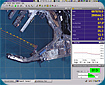
When sounding is carried out, a the surveying points (coordinates and depth) with a given frequency (10 measurements in 1 second) are recorded on a computer (using HidroPRO 2.0 software) and (optionally) on an echogram.
At-processing measurements at the measured depth of a correction for changes in water level. All depths are determined with respect to "0" depth of the site.
the survey results are processed using the HidroPRO 2.0 software and presented in an electronic form.
Custom works
Working with sonar equipment and a magnetometer
Sonar survey is performed to detect objects of man-made and naturally occurring towering above the bottom. Magnetometer survey of the site is performed to detect a variety of metal objects.
Calculation of the dredging works volume
to calculate the dredge CREDO and HidroPRO 2.0 software is used. Two surfaces are compared (i.e. the depth of dredging based on results of the current design works). Volumes are calculated up to 1 cubic meter and the results are considered satisfactory for divergence calculations on the 2nd program no more than 1-2%.
Operational support of the dredging fleet.
To ensure quality and continuity of dredging works, surveying is performed with the required frequency. Plan of the sounding is promptly submitted to the dredging fleet in the form of electronic array of color depths.